Bali Tourism Tax
Bali Shares Updates On Tourism Tax Spending As Holidaymakers Encouraged To Pay Up
Latest figures indicate that the number of tourists visiting Bali is increasing compared to 2024. By the end of the year, the province is on track to see a 10-12% increase in the number of international tourists.
As visitor numbers rise, officials are calling for all tourists to remember to pay their Tourism Tax Levy contribution.
The Bali Tourism Tax Levy was introduced in February 2024, and while the IDR 150,000 is a mandatory requirement for all international tourists, by the end of the first year of the policy, it was clear that as few as 35% of visitors had made their payment.
Data from the Bali Provincial Government shows that between January and June 2025, the province had received IDR 168 billion in tourism tax levy revenue, which equates to USD 10.5 million.
Bali Governor Wayan Koster revealed to reporters that on one record-breaking day, Bali received IDR 933 million in tourism tax fees, equating to USD 57,000.
Koster told reporters, “If this trend continues, the potential annual revenue is estimated to reach IDR 340 billion.”
Governor Koster has also committed to optimising tourism tax revenue spending and confirmed that he is working with a range of stakeholders, including in the hotel sector, to ensure that the funds are spent in ways that benefit Bali residents, the environment, and tourists.
Tourists traveling to Bali this high season are reminded that the Bali Tourism Tax Levy fee is non-negotiable.
The easiest way to pay the IDR 150,000 per person fee is via the LoveBali website. It is now possible to make the payment for multiple travelers in a group in one go. Simply head to the LoveBali website, and on the homepage, select ‘Group’ and proceed with the steps on screen.
Travelers will need to have their passport number and email address readily available. The first tourist listed in a group application will receive the invoice for the entire group’s payment, although separate QR-code vouchers will be sent via email to each group member.
The alternative option to paying on the LoveBali website is to make payment on arrival at I Gusti Ngurah Rai International Airport. However, many tourists have noted that this adds an extra step in the arrivals process.
Regardless of where tourists make their payment, they will be issued with a QR-code voucher that they must keep close at hand throughout the duration of their time in Bali.
Tourism Task Force Officers and officers from the Bali Tourism Office regularly conduct spot checks on tourists visiting top attractions, including destinations like Tanah Lot Temple and the Jatiluwih Rice Terraces.
Tourists who are found not to have yet paid their Tourism Tax Levy payment will be asked to pay on the spot. All Bali Tourism Tax Levy payments must be made on a debit or credit card, and it is not possible to pay in cash.
Tourists and travelers heading to Bali are advised to complete their Tourism Tax Levy application themselves and not use a third-party service.
There is now a verification feature on the LoveBali website for tourists who have been issued their QR-code voucher by a third party to check the legitimacy of the document.
The Bali Provincial Government explains that the Bali Tourism Tax Levy and “Love Bali is a movement started by the Bali Provincial Government to enforce a new policy, the Comprehensive Development Plan. The goal is to preserve the integrity and balance of Bali’s nature, its people, and their culture.”
ourists are reminded that it is not yet possible to make their visa on arrival payment and their Bali Tourism Tax Levy payment in one go.
This is because the Bali Tourism Tax Levy is a provincial tax system managed by the government of Bali, and the visa system is managed by the Indonesian Immigration, overseen by the central government.
Extreme Weather Warnings Issued For Tourism Hotspots In Bali
Tourists in Bali are being urged to pay attention to weather warnings issued around the province this week.
Extreme and unseasonable weather events have impacted many parts of the island, causing trees to fall, resulting in dangerously high waves, and even the appearance of a sinkhole.
The Meteorology, Climatology, and Geophysics Agency (BBMKG) for Bali has issued an early warning of potential high sea waves that could reach 6 meters in the southern waters of Bali Island. The brunt of the waves is predicted to hit between July 8th and 11th.
Speaking to reporters, Weather Forecaster, Luh Eka Arisanti, explained that the high waves and unseasonable rain that fell over Bali over the last few days are due to active Equatorial Rossby waves and Kelvin waves that increase cloud formations in the Bali region.
Arisanti added, “Another factor is also due to the weakening of the Australian monsoon winds, causing humidity in Bali to increase significantly. Wet air masses are now concentrated from the surface layer to the 700 mb layer, or equivalent to 3,000 meters above sea level.”
Arisanti confirmed that the highest rainfall was recorded in Tabanan Regency, which saw 204mm on Sunday, 6th July. Extreme rainfall is defined as any amount of rainfall exceeding 150mm per day.
Arisanti explained, “Another factor is also due to the weakening of the Australian monsoon winds, causing humidity in Bali to increase significantly. Wet air masses are now concentrated from the surface layer to the 700 mb layer, or equivalent to 3,000 meters above sea level.”
One of the worst-affected areas in Tabanan Regency, which is renowned for its tourism destinations such as the Jatiluwih Rice Terraces and Tanah Lot Temple, was Pangkungkarung Village and its surrounding communities.
The Bali Provincial Natural Disaster Management Agency (Bali BPBD), led by Chief Executive Gede Teja, confirmed that 29 families were impacted by the flooding and that emergency assistance had been sent to support them. The Bali BPBD also issued warnings for the public to be aware of hydrometeorological disasters, such as floods, flash floods, landslides, and fallen trees, due to the extreme weather.
Heavy rain across the province has caused landslides, flooding, fallen trees, and even a major sinkhole to appear on the Denpasar-Gilimanuk Highway. The sinkhole appeared in the village of Bajera, in Tabaan Regency, around 5km from Soka Beach, on Monday, 7th July.
The sinkhole will now require traffic diversions to be in place along the Gilimanuk-Denpasar Highway and in Tabanan Regency for at least a month.
The Head of the National Road Implementation Work Unit of Bali Province, I Nyoman Yasmara, told reporters on Tuesday, 8th July, “Heavy rain caused large holes in the road. The government is currently carrying out repairs. The work is estimated to be completed in the next month.”
Speaking separately, the Bali Police Traffic Director, Senior Commissioner Turmudi, clarified, “The police directed two-wheeled and four-wheeled vehicles via an alternative route in Bajera Village, precisely behind Bajera Market.”
His comments were backed by Selemadeg Police Chief, Commissioner I Wayan Suastika, who explained, “For the time being, Denpasar-Gilimanuk traffic flow is being diverted via the Singaraja route.”
Tourists in Bali, whether on land or by the coast, are being advised to closely monitor wave and weather forecasts, as well as volcanic activity in Indonesia. In the last week, three of the country’s major volcanoes erupted, with an eruption from Mount Lewotobi Laki Laki on Monday, 7th July impacting Australia-bound flights and a series of flights to China, South Korea, and Singapore.
On Monday, 7th July, at least 18 flights were impacted by the volcanic eruption in the Flores Islands, though the General Manager of Ngurah Rai International Airport, Ahmad Syaugi Shahab, confirmed that regular order was resumed by Tuesday morning, noting “All flights are planned to depart today.”
Shahab told the media, “We remind all prospective passengers to reconfirm their flight schedules with each airline and be at the airport 2-3 hours before the flight schedule.”
Bali Tourists Must Pay Attention To Volcanic Activity
Tourists traveling to Bali or across Indonesia are advised to closely monitor volcanic activity in the country.
Volcanic activity across Indonesia is increasing, especially on the islands neighbouring Bali, and eruptions have been impacting flights.
Volcanic activity from Indonesia’s Mount Lewotobi Laki Laki has been increasing over the last 10 months. On June 17th, the volcano in Flores erupted, releasing an ash cloud 11km into the air.
The eruption triggered the authorities to put Mount Lewotobi Laki Laki back on the highest level of alert, and the eruption caused major delays and travel disruptions at Bali’s I Gusti Ngurah Rai International Airport.
On Monday, 7th July 2025, Mount Lewotobi Laki erupted once again. Indonesia’s MAGMA Agency confirmed that the volcano spewed a mixed cloud of ash, lava, and gas 19km into the air, creating an avalanche and lava flow for 5km down the volcano.
Monday’s eruption impacts at least three flights to I Gusti Ngurah Rai International Airport. A Virgin Australia spokesperson told reporters, “Some Virgin Australia Bali services have been cancelled following the eruption of Mount Lewotobi earlier today.”
Adding “The safety of our guests and crew is our highest priority, and our team of expert meteorologists is closely monitoring the situation and ash cloud activity…We regret the impact of this on guests’ travel plans and encourage guests travelling to or from Bali to closely monitor their flight status via the Virgin Australia website or app.”
A spokesperson from Qantas told reporters, “Our meteorologists and operations teams are closely monitoring the movement of volcanic ash from the latest eruption of Mount Lewotobi in Indonesia.” Adding “Safety is always our top priority, and we will contact customers directly if their flight is disrupted.”
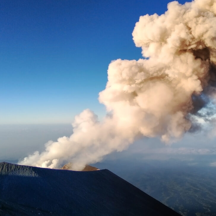
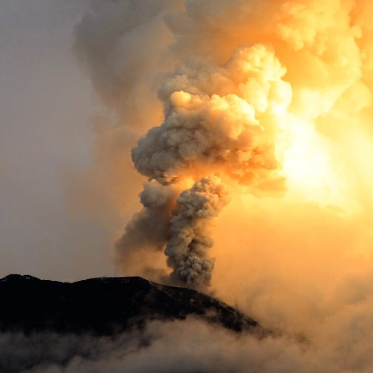
It is not only Mount Lewotobi Laki Laki in the Flores Islands that is experiencing heightened activity, but also Mount Ruang in East Java. On Monday, 7th July, the volcano, which is located at the border of Jember Regency between Bondowoso and Banyuwangi in East Java, spewed an ash cloud 1000m above its peak.
The Mount Raung Observation Post Officer, Burhan Alethea, confirmed, “There was an eruption of Mount Raung with the height of the eruption column observed at around 1,000 meters above the peak or 4,332 meters above sea level (masl).” Mount Raung erupted again at 3.21 am local time. Alethea added, “The height of the eruption column was observed to be around 800 meters above the peak or 4,132 meters above sea level.”
He urged, “The public and visitors or tourists are not allowed to approach the eruption center in the peak crater within a radius of three kilometers, descend the caldera, and spend the night in the crater area.”
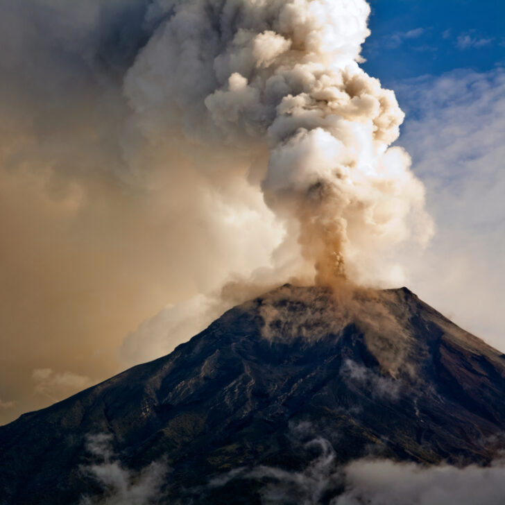
Data from Mount Raung Observation Post in Songgon, Banyuwangi, recorded that since January to July 2, 2025, there have been 43 eruptions. The height of the eruption column varies between 400 to 2,000 meters above the peak. In a media statement issued last week, the Mount Raung Observation Post Officer, Agung Tri Subeki, shared, “During June 2025, Mount Raung erupted almost every day.”
Speaking separately, the Head of the Geological Agency of the Ministry of Energy and Mineral Resources (ESDM), Muhammad Wafid, previously confirmed that the latest evaluation showed that Mount Raung remains on alert despite the continuous eruption activity, adding, “The status of Mount Raung is still Level II.”
On Friday, 4th July, Mount Seramu, which sits at the border of Lumajang and Malang Regency in East Java, also saw a significant eruption. Visibility of the eruptions was obscured by dense fog. Seismic activity was also recorded from Mount Seramu in the three days prior.
Mount Semeru Observation Post Officer, Ghufron Alwi, reported that the first eruption on Friday, 4th July, occurred at 04.47 local time with a maximum amplitude of 22 mm and a duration of 124 seconds.
He added, “Mount Semeru erupted again at 08.50 Western Indonesia Time, and the height of the eruption column was not observed. The second eruption was also recorded with a maximum amplitude of 22 mm and a duration of 108 seconds.” Mount Seramnu reminds me of a Level II warning. A no-go zone has been put in place 3km around the centre of the peak.
All articles are provided by “The Bali Sun“
Please contact us for information on North Bali property